05 November, 2015

AQAP Stronghold Becomes Tropical Cyclone Magnet: More Divine Retribution?

Cyclone Chapala was, once again, a storm for the record books, to say the least. In the western hemisphere, this behemoth would be called a Category 4 hurricane, but this cyclone formed not in the Atlantic… or the eastern Pacific… or the western Pacific (where they're called typhoons)… but in the Indian Ocean. Not unprecedented if it happened in the Bay of Bengal, but in the Arabian Sea? Yup, that's precisely where this monster formed. Also not unprecedented, but most storms there end up either being fish storms or making landfall in western India. Where exactly was the landfall location of this beast, by stark contrast? The typically extremely arid city of Al-Mukalla, Yemen.

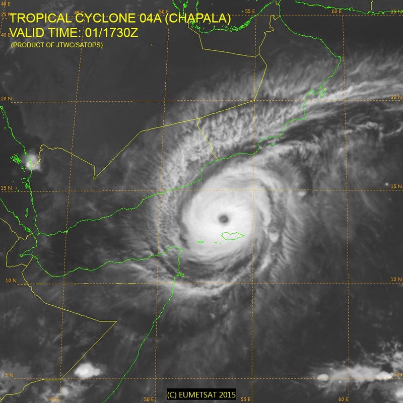
Cyclone Chapala as it approached the Yemeni coast on All Saints' Day, 2015. Two days later, on the day immediately following All Souls' Day, this beast would hammer the city of al-Mukalla, occupied by AQAP throughout much of 2015, with hurricane-force winds, storm surge, and a decade of rain in less than 24 hours, causing a flood of biblical proportions.


The devastation (and devastation potential) was certainly hard to underestimate, that's for sure. Tropical cyclones not only bring fierce winds and city-busting storm surge with them, but also typically dump double-digit rainfall wherever they make landfall. This area, however, typically gets less than 2 inches of rain per year. The soil there is very much like Arizona's as a result: extremely impervious to water. When it rains in the desert, it floods, and when the desert gets a decade worth of rain in less than 24 hours, it floods big time. As if that deluge wasn't enough, guess what? Another tropical depression just formed, and is forecast to hit the same area as another hurricane-strength storm in the next week or two (Update: this one has been given the name Megh).

Making matters worse, the country has been in a civil war for decades. While the government has tried to keep the country in order, Islamist groups like Al-Qaeda in the Arabian Peninsula (AQAP) have tried to tear Yemen apart. So, without much further ado, what city is AQAP's de facto capital? Al-Mukalla. This arid city turned tropical cyclone magnet is also a city that such notorious terrorists as Nasir al-Wuhayshi, founder of the AQAP branch, and Nasser bin Ali al-Ansi, commander of the two men who perpetrated the Charlie Hebdo shooting, called (and their group still calls) home.

In October 2014, I wrote and published another post that makes a hard case about areas where persecution of Christians takes place and how natural disasters are often precariously timed to coincide with days following Jewish and Christian holidays. Cyclone Chapala made landfall on November 3. November 2 is All Souls' Day — or "la Día de los Muertos" in Spanish — and at least in the Catholic Church is a very, *very* important holiday. Could Cyclone Chapala be yet another example — in addition to the AD 79 Vesuvius eruption and 2004 Indian Ocean earthquake/tsunami 1-2 punch — of this kind of divine retribution at work?

The interpretation of this is up to the reader, but it definitely makes sense. Av 10, December 26, and November 3 are all days immediately following important Jewish (Tisha b'Av) and Christian (Christmas, All Souls' Day) holidays, to be sure. Although A.D. 79, 2004, and 2015 are all worlds apart in a historical context, these disasters IMO are a reminder of who's in charge here.

19 July, 2015

Dolores Deluge: Rare July Precipitation Event with an El Niño Fueled Tropical Connection

19 July 2015. For the past two days, conditions have seemingly gone topsy-turvy for some here in Southern California during what is typically the driest month of the year. An Angels game had to be cancelled due to "inclement weather" for the first time since 1995. Two formerly raging wildfires, including one that scorched 20 cars on the 15 freeway, are now 100% contained thanks to extremely high humidity and rare July rainfall. People in an assisted living community had to evacuate, not due to fire, but due to flash flooding ― and this is in July, when average annual precipitation is only 0.02 of an inch. People have been quick to directly blame El Niño, but in actuality, it's really only indirectly related.

Hurricane Dolores as a Category 4 storm Wednesday evening, hammering Socorro Island. Eventually, after dissipating over cooler waters, this system shot a plume of moisture up the coast as a tropical storm, then made landfall in SoCal as a remnant low
The real source of this rare July bonus moisture was, yes, that's right, former Category 4 Hurricane Dolores. On Wednesday, Socorro Island, a volcanic island about 200 miles southwest of Cabo San Lucas that contains a Mexican naval base, got hammered by sustained winds clocking in at 130mph, coupled with a 15-foot storm surge and horizontal rain, all from this beast. After that, the storm began to move into cooler waters and, naturally, weaken... ah, but slowly. Dolores remained a weak tropical storm as far north as Vizcaíno ― rare for July ― and produced tropical storm force winds even after becoming post-tropical, as far north as San Clemente Island. The result? A boatload of tropical moisture streaming over Southern California during what is usually the driest month of the year.

El Niño years tend to make this more likely to happen, for several reasons. One is the weakening and/or reversal of the trade winds. Normally, they blow from east to west ― that is typically why hurricanes also move in that direction. When the trades weaken or reverse, westward movement slows. Second is the large-scale collapse of blocking patterns that typically dominate over much of the North Pacific during the summer months. This allows low pressure systems to form in the North Pacific even during the dry season ― troughs that can grab tropical cyclones and pull them north. Third, with the resulting overall lack of upwelling, waters immediately off the California and South American coasts become much warmer than normal, giving tropical cyclones more overall fuel that can sustain them further from the tropics than usual. All of these factors put together can cause some rather interesting effects as the hurricane season in the eastern Pacific basin (which happens to be the very source of the wind shear that suppresses Atlantic activity) rolls on up.

Although this kind of situation is definitely the first of its kind for July in the known historical record, it's not the first of its kind period. In September 1997, for example, moisture from Hurricane Linda ― which currently holds the record for strongest in Eastern Pacific history, although probably not for long ― streamed across California, causing torrential rains and even hail the size of golf balls in some locations. That same year, moisture from the much weaker Hurricane Nora also managed to cause some interesting totals, especially in the Inland Empire, where flooding was rampant. Going further back into history, one of these eastern Pacific behemoths made landfall in Long Beach as a strong tropical storm back in 1939 ― also an El Niño year ― and even further back, in 1858 — again, El Niño — a Category 1 hurricane brought 85mph sustained winds and 10 feet of storm surge to San Diego.

Given how many impacts we've had already ― heck, even way back in May and early June we had some remnant moisture from Hurricane Blanca as well ― it shudders me to think of possible impacts later in this season, including possible repeats of the 1939 and/or 1858 events, given that 2015 accumulated cyclone energy is already ahead of 1997 levels. Although, I for one would definitely take a direct hit from a tropical cyclone as an added bonus on top of already extreme winter El Niño impacts over this drought any day… catch-22, I guess. These are definitely exciting times indeed.

06 July, 2015

July 2015 ENSO update: Equatorial anomalies, WWB's continue to ramp up

If I haven't been posting much to this blog in recent weeks/months, I apologize. Part of the reason has been my exceptionally high Twitter activity… ah, and activity there tends to be a distraction. Anyhow, I've been using a myriad of tools to track this pending El Niño event – everything from retweets, to WWB time-lon forecasts, to surface current anomalies, to observed SST anomalies, to SST anomaly forecasts, and all of them are beyond impressive.

SST anomalies: Exceptionally impressive to say the least


My last update (in May) showed a marginally warm strip along the equator. Now, however, it's July. What do we have here? Well…


Compare that to May, and clearly it's a sign that this event is, hands-down, the strongest since 1997. Do SST anomalies alone tell the whole story? Of course not, but it goes to show just how impressive this event is, with more WWB's and downwelling Kelvin waves (next paragraphs) on the way. What makes this map clearly differ from 2014 (especially) is the Banda Sea cold pool: it forces high pressure over Indonesia, thus keeping the atmospheric response locked in place.

Westerly trades: Cross-equatorial tropical cyclones, redux


You may recall that what initially kickstarted this event was a pair of tropical cyclones on both sides of the equator at the same longitude back in March: Cyclone Pam (yes, that's right, that monster, the one that ended up being a direct hit on Vanuatu, completely obliterating heavily populated portions of the island) on one side of the equator, and Tropical Storm Bavi (which never made it to typhoon status) on the other. Fast-forward to July 1 Australian time (technically late June 30 in California) and that exact same thing happened again: TS Chan-hom on one side of the equator, Cyclone Raquel (also a TS when the Saffir-Simpson Scale is applied) on the other. Although Cyclone Raquel was clearly weaker than Pam, it was still paired with another cyclone on the opposite side of the equator. When this occurs, it's like a WWB pitching machine: winds rotate counterclockwise north of the equator, clockwise south of it, and between the two, winds have only one way to blow: from W. Here:


As you can clearly see, what we're looking at is easily the most powerful westerly wind burst since March, and moreover, when Raquel dissipated, the Southern Hemisphere Booster followed right behind. Now, there's a pressure gradient of high in W, low in E, which can keep that WWB progressing further E. In ~5 days, this westerly wind burst could reach the far E Pacific, where more hurricanes (starting with Dolores) should form. For a review: the word "typhoon" is only used W of the date line; E of it, they're still hurricanes.

Kelvin waves: 3 and counting


You may recall that the April/May Kelvin wave was set off by the westerly wind burst induced by the Pam/Bavi cross-equatorial pair. However, the May westerly wind burst set off a second downwelling Kelvin wave. While the Kelvin wave in April only contained small patches of +6°C anomalies at depth, this one brought with it anomalies at depth of +6°C across the board, with patchy +7°C T-Depth anomalies. Then, Chan-hom and Raquel pitched in, and the result was a third Kelvin wave. Although it doesn't look too impressive at the moment, it's very fast-moving: in just a matter of, like, 3 days, it's gone from 165°E to the date line, and the WWB that spawned it continues to move east as well. On top of that, there's now a strong MJO superimposed on top of the Niño signal, adding to those westerly anomalies, and as mentioned above, there's also anomalous cooling of the Banda Sea helping to lock that signal in place.

Conclusion


So, we've got everything coupled… it's just a waiting game now. Let's see how strong this event gets, shall we? It would definitely mean the world to us in CA, especially in conjunction with cooling AMO, since cool Atlantic in general tends to want to shift the storm track south, and with the Hudson Bay now also heating up with warm anomalies, blocking should reposition over Canada… everything looks to be coming together. Everyone, this is going to be a wild ride.

25 November, 2014

Coachella Valley: The Next Black Sea?

I was once skeptical of the possibility of a major hurricane directly impacting Southern California. After all, the waters off the coast are indeed simply too cold to sustain hurricanes... and the only ones that manage to veer north usually move too slowly over those cold waters and fizzle... with a few rare exceptions, of course, and by the time those rare exceptions manage to reach SoCal, they're only tropical storms to category 1 hurricanes at best. Likewise, if they manage to take the trek up the Gulf of California/Sea of Cortez, which is indeed some of the warmest water in the entire Eastern Pacific basin, with summertime SSTs reaching as high as 90°F on a regular basis, they'd still make landfall in northern Mexico, and have to cross a lot of land to reach SoCal. Or so I thought.

The first clue that I managed to dig up suggesting that the Gulf could pose a hurricane threat, at least to the Inland Empire, came from looking up the elevation of the surface of the Salton Sea. The reading? 237 feet below sea level. That alone raises a bright red flag: Even New Orleans was only about 10 feet below sea level when Katrina hit. What's more, the entire Coachella Valley, more or less, is a bowl, and it's the site of an ancient lake bed that once filled the entire region... the ancient lake, if I'm not mistaken, stretched from what is now Mexicali all the way to what is now Palm Springs. That's one massive lake... and the fact that its floor is now the site of a major population center should be enough to freak out anyone.

Then, I managed to Google " 'sea level rise' 'Coachella Valley' " (inside quotes included, as double quotes). I noticed a KCET article that was rather disturbing, depicting what would happen if climate change raised the level of the Gulf by only a few feet. Then, I switched over to the images tab. That's when I noticed something very disturbing, in regards to the Coachella Valley's only lifeline:


As you can see, the only high ground between the Salton Sea and the Gulf of California is, at most, only about 7 or 8 feet above sea level. What's more, the 20-foot line ― the height of a typical major hurricane storm surge, especially in a warm, shallow environment like the Gulf of California ― is almost the entire width of the Gulf itself. A storm surge of that size eroding a path into a depression like the Salton Sink? Yeah, it's almost impossible to fathom such a catastrophe. You're looking at a region from Mexicali all the way to Palm Springs being completely submerged.

What's more, as previously mentioned, SSTs in the upper-80's to near 90 degrees are well within rapid deepening territory. When Odile managed to traverse the northern Gulf as a tropical storm back in September 2014, guess what happened? The storm grew from a weak to a strong one, with, at their peak, about 60mph winds, before making a second landfall on the northeastern shore of the Gulf. Thankfully, however, Odile had weakened to a tropical storm from, at the first landfall, a Category 4 hurricane, prior to even entering the Gulf... and what's more, this storm could have been much worse.

Remember, what was steering Odile away was an area of high pressure, whose western edge (and clockwise rotation) was already at its easternmost point and began to move westward, keeping Odile over Baja. Had Odile gotten sucked into that high only a day... or two... or three earlier, so that Odile made its first clipper landfall in Puerto Vallarta before moving up the Gulf, I guarantee you Hurricane Odile would have been a 5 by the time it reached the northern Gulf... and then, as the high began to build again, it would have pushed Odile northwestward, resulting in Odile hooking to the west instead of the east. That makes Odile our closest call so far to this.

In fact, those warm Gulf of Mexico waters in the notorious Loop Current that intensified Katrina were also around the same temperature: near 90°F. The difference, however, is that those extreme SSTs, while incredibly anomalous in the Gulf of Mexico, are commonplace in the Gulf of California. So then why haven't there been rapidly intensifying hurricanes in the Gulf of California before? There's a simple explanation for that: it's got a lot more land in the way. Most of the storms that have managed to go up the Gulf have first run into either the Baja Peninsula (mountainous terrain) or mainland Mexico (more mountainous terrain). You need the steering patterns to be near-perfect for this to happen: a strong, blocking high over the western Gulf of Mexico to the east, and, most importantly, a clockwise flow around the high that pushes moisture directly over the Mojave Desert, where the thermal low then grabs it, intensifies due to convection, and rotates, locking that blocking high in place. Then, you need a hurricane that takes a near-perfect path, so that it could get caught up in that, clipping the headland near Puerto Vallarta, entering the Gulf of California, rapidly intensifying, and making its second landfall just to the west of the Colorado River Delta. Yeah, it's not a question of if, it's a question of when... and when it does happen, the results would be disastrous indeed.

Not only would such a storm be disastrous for the Coachella Valley, but, if it is caught by that thermal low and takes that left turn as an intense hurricane, it could also remain a category 3 or higher monster even as it exits the region, provided it misses the San Jacinto and/or San Bernardino mountains, and enters the Los Angeles Basin. The resulting wind (and even tornado) damage, not to mention torrential rainfall, could pose even more problems. Remember, if that basin fills, that water is going to come in contact with not only the hot Salton Sea but also the hot ground. That will in turn add more heat to the incoming storm surge water, moving over a region that is, mind you, 237 feet below sea level, and that heat could then continue to sustain the hurricane as it passes through that inland sea that it creates. So, it would end up continuing to rapidly intensify as it makes that westward hook. Yeah, you can see where this is going: a recipe for disaster indeed.

29 October, 2014

10th of Av, 26th of December: Divine Retribution As Hard Evidence Against Atheism

One of the key questions atheists use, and I've clearly noticed this myself, is something kind of ridiculous: they use the category error of asking for geological and/or historical evidence of a God whose kingdom is clearly "not of this world". They go and claim that in order to believe, God must be a physical, tangible being and not the invisible Holy Spirit that He really is. What they don't realize, however, is what happens in areas where persecution occurs: catastrophes line up so closely with Jewish and Christian holidays that mere coincidence becomes all the more improbable compared to just believing.

Av 9, A.D. 70. Roman authorities get word of a massive revolt involving thousands of Israelites, some Jewish, some newly Christian, wanting to get even with the empire that longs so much to want to rule them. In response, they send a massive new army to crush the rebellion, and the army marches on the very temple that they worship in. Under the command of General Titus, who would become another Roman emperor a few years later, this army burns the Temple, crucifies rebelling men by the hundreds of thousands, and kidnaps over 30,000 Israelite women and children for use as slaves, forced to either work themselves to death or, worse, offer sexual services and serve as baby factories for the Roman elite. Since Pompeii and Herculaneum were both resort towns that the emperor and his wealthy servants loved to hang out in, as wicked as they were, most of this slavery and forced servitude also happened in the Pompeii region. Throughout that very region, of course, there have also been countless graffiti findings that warn their Roman captors of utter destruction ("poinium", "cherem") to come, including graffiti that manages to analogize Pompeii and Herculaneum with Sodom and Gomorrah. That destruction wouldn't be too long in coming.

Av 10, A.D. 79. It seems like just another day in the elite Roman playground that is the Pompeii region, and the slavery and sexual exploitation of Jews and Christians is as prevalent as ever. Then, suddenly, the ground begins to rumble. The mountain above them ― Vesuvius ― begins to blow off some steam... but by this time, it's too late. The volcano blows its top. A huge eruption column blows ash 20 miles into the sky. Day suddenly turns to night. Ash begins to rain down on this elite Roman playground for hours, and the Roman elite start to wonder what the heck is going on... ah, but the Christian and Jewish captives knew all along that this was payback for what the Romans did to them in Jerusalem nine years earlier. Then, it happens. The volcano becomes exhausted of all its magma reserves, and the eruption column becomes too heavy. It then collapses as a series of massive pyroclastic flows. Herculaneum, upwind of the column, is the first to go. Pompeii follows. Over 16,000 of the Roman elite are killed, while the slaves, shielded from the ash by thick underground bunkers, manage to make it out alive the way the prisoners in Saint-Pierre did when Mount Pelee erupted. After completely burying Pompeii in ash, the pyroclastic flow proceeds to blast its way into the Bay of Naples, where it displaces water. The resulting tsunami devastates the port city of Stabiae, which is probably the most important port city in the entire Roman Empire, since it's the closest port city to Rome. Without it, Rome's residents are helplessly marooned off from the rest of the empire. A year later, in A.D. 80, and certainly not within enough time for Stabiae to be rebuilt, an urban conflagration breaks out in Rome. With no port of Stabiae to get supplies and people in and out of the city, the city burns to the ground, taking tens of thousands more Romans with it. The destruction of Stabiae also bears a stark resemblance to another, more modern act of divine retribution.

It begins in a country where Islam is the official religion and Christianity is brutally repressed under dictator Suharto's regime for over 20 years, and continues long afterward as the radicalized Muslims that Suharto forms an alliance with suddenly roam free. That country is Indonesia. It's a nation where an uncle of mine is in fact a missionary, managing to overcome countless acts of violence to save people. In Indonesia, most Christians happen to live in the islands surrounding Western New Guinea and Timor, which is basically cut in half between Indonesia and the young independent Christian nation of Timor-Leste. Most of the radical, Christian-killing Muslims, in groups such as Jemmah Islamiyah and the notoriously ISIS-like, caliphate-wannabe Free Aceh Movement, used to be concentrated in the main islands of Java and Sumatra. It's here that radical Muslim groups used to go on a rampage against Christians. They ransacked churches. They attacked Christians in the most horrific means imaginable, mostly through either beheading or burning alive. People celebrating Christian holidays, like Christmas, were especially easy targets for their brutal oppression. Then came the day that Yahweh would once again have His payback, also with timing relative to a persecuted holiday that should be noted: December 26, 2004.

It was on this day that a killer subduction zone, the Sunda Megathrust, began to slip, epicentered approximately 50 miles off the Acehnese coast. The fault then continues to rupture north and south along a good chunk of its length, finally stopping as a 600-mile-long rupture. Seismic waves radiate out from this rupture in all directions, lasting as long as 6 minutes in duration. The moment magnitude of the quake is registered by seismologists as 9.1. During this hellishly long shaking, numerous unreinforced masonry structures ― including most mosques, which are notoriously URM ― are extensively damaged or destroyed, and falling objects cause numerous injuries, becoming strewn all over the place. Minutes later, the Indian Ocean suddenly retreats from the coast of extreme northwestern Indonesia, where the most Islamic extremism is concentrated.

Then, an ominous white crest appears on the horizon. It's a tsunami. The ground that Banda Aceh is on is almost perfectly flat, and there's no high ground for several miles. The tsunami uses these fallen unreinforced masonry objects as weapons, smashing countless buildings already damaged by the quake and using the resulting debris to then smash more buildings, ultimately flattening the entire city. Buildings that survived the quake soon become moved, displaced, flattened ruins. Most importantly, however, these people had absolutely no clue what a tsunami was or how to survive it. The result? Of the 220,000+ casualties in this dreaded 2004 disaster, over 150,000 were in the region where the Jemmah Islamiyah and GAM insurgencies were most active, in the proposed capital city of the separatist caliphate, Banda Aceh, and of those 150,000, a good 30,000 or so were indeed members of those radical Muslim groups who always loved persecuting the Christians that they thought were a nuisance. Most Christians, however, were in eastern Indonesia, shielded from the tsunami by the main islands of Sumatra and Java, and were almost all completely unscathed.

There's clearly an interesting pattern here. Geology can only involve guesswork as to when events like these might occur, even today. Even with all the modern technology we have at our disposal, no one in their right mind would ever come close to saying that "this quake will happen on precisely this day" or "this volcano will certainly erupt on such and such a day". There's just no way. For the timing of these events to suddenly tweak itself so perfectly as to, in both cases, occur exactly one day after a Jewish or Christian holiday in both cases, that certainly can't happen blindly. Some outside force, like, oh, I don't know, the Holy Spirit, must be at work, manipulating the timing, either delaying an eruption so it builds up a boatload of pressure and goes off as a much bigger eruption on precisely the date it's predestined to, or delaying an earthquake so that it becomes much bigger and also goes off at a predestined date. If these events could happen on a whim, that's exactly what they would do: occur on a whim, which would mean frequently and subtly. The fact that these events are happening in such perfect alignment with brutally suppressed Judeo-Christian holidays certainly can't be mere coincidence.

02 October, 2014

156 years later, the 1858 San Diego Hurricane still raises eyebrows

156 years ago today, a hurricane which formed off the coasts of Mexico and Central America several days prior took a very unusual course. Most of them either A, move westward, or B, move slowly over cold water, which thus has enough time to make them die out. Not this one. After missing the southern tip of Baja, this menace was picked up by a trough and swung rapidly northward. Having been a category 3 storm at peak intensity, it weakened down to a category 1, then briefly re-intensified to a 2 due to the pressure gradient influence of a ridge behind that trough (not to mention a patch of unusually warm El Niño water)... then back down to a 1, dangerously close to, where? None other than San Diego, California:


This monster hurricane caused damage that we can't even fathom today. It tore roofs off houses. It created a storm surge that overtopped Coronado Island, blasted across San Diego Harbor, flooded a good chunk of the city (well, actually, small town at the time), and shoved three large US Navy schooners, the USS Plutus, the USS Lovely Flora, and the USS X.L., completely aground. That's a key point: Schooners aren't just boats, they're massive ships. In order to completely beach (!) a 200-foot schooner with the massive keel that it has, much less three of them, you need at least a 15-foot storm surge. On top of all that, rain fell in buckets, enough to overtop rain gauges and cause normally dry, ephemeral riverbeds to rapidly overflow their banks. Due to the long time it took news to travel back in 1858, however, the folks on the east coast didn't even know about the damage until several months later.

When I bring up this storm, people are literally freaked out... and of course, I don't blame them. Why? Because if it happened before, it will happen again. What makes such a storm so destructive for only a category 1 hurricane is the sheer size. Remember what kind of storm surge Hurricane Sandy caused? Sandy was also a category 1, but the wind radius, just like the wind radii of most intense East Pacific hurricanes, was a good 500 miles out from the center. That is key to a storm surge catastrophe that could make Marie seem like a mere dress rehearsal.

See, when hurricanes are forced to move away from warm water at speeds too fast to dissipate in time, they begin to compensate for the lack of fuel by spreading out their wind diameters. A storm that's only 200 miles across at peak intensity can end up expanding to 1000 miles across when it gets to California (or New York)... and likewise, one that's 500 miles across at peak intensity can end up being 2000 miles across in that same case. The larger the storm's radius, the more water it displaces. Translation: it's a recipe for disaster. Something halfway between Sandy and Ike in terms of storm surge impacts.

Then, we come to the second major impact: rain. Rain that can amount to a staggering 2 inches per hour — on par with the kind of rainfall rates that Hurricane Irene brought to New York and New Jersey. When that gets dumped on mountainous terrain, guess what that causes? Extreme flooding. In 1976, our neighbors to the east — in Ocotillo — got a glimpse of that potential for catastrophic flooding when Hurricane Kathleen made landfall in Baja and moved north across the border as a tropical storm. As much as 14 inches of rain fell in a matter of hours, causing a dry creek bed that flows toward Ocotillo from the Baja mountains to suddenly explode into a 40-foot wall of water that blasted its way through the town, flattening everything in its path. When the storm was over, it looked as if a tsunami came through the town. Expect a repeat of that in multiple locations should a repeat of the 1858 storm occur.

And that's the thing: history does repeat itself. It's not a question of if, but WHEN SoCal will get hit again. Also, it's El Niño events like the ones in 1997, 2009, and, yes, 2014 that tend to result in far more powerful East Pacific hurricanes... not to mention, of course, that during the early fall months, the winter storms also begin to pick up strength and have more of a tendency to fling storms northward. Santa Ana pressure gradients also play a part, as do those whisps of forced evaporation that Santa Ana winds pick up when they hit the water: they not only instantly transform the Santa Ana air from dry to moist, but they also increase the salinity of the water and force it to temporarily downwell. Hopefully it's not too late. If it is, however, better hunker down...

02 August, 2014

Project Seal: Implausible Then, Certainly Possible Now

In the 1940's, before the nuclear age, during World War II, some recently declassified documents depict something extraordinary: military scientists experimented with sending tsunamis into the Japanese coastline using explosives, to wipe out those civilians who were defending the coastline against an invasion with pitchforks and keep the human cost of an invasion down. The plan was shelved after the military scientists determined that it would take some 2 metric kilotons of explosives to create such a wave... at least if those explosives are placed in a straight line.

One thing that really intrigues me about how tsunamis can be focused, from a fluid dynamics standpoint, into a relatively small area, is the Cascadia earthquake and tsunami of 1700. According to computer models, there's one portion of the wave, as it leaves Cascadia, that's significantly larger and more destructive as it travels across the Pacific than any other part:


Note how that portion of the departing tsunami, which appears to also have a dent in it, almost conforms to the shape of the subduction zone that created it: all that tsunami energy appears to be focused on that one point, where the wave is both longer AND taller than it was in Cascadia. Could explosives do the same when placed in that concave pattern?

Despite how far-fetched it may sound, accidents involving man-made explosives have created tsunamis before. Take the incident in Halifax in 1917, for example. The SS Mont-Blanc, a cargo ship about 1.5 times the size of your average jumbo jet (which is not very big for a cargo ship, let's be clear), sailed across the Atlantic, loaded from bow to stern with military high-explosive cargo, in the form of mostly nitrocellulose, TNT, and picric acid. When the Mont-Blanc got to Halifax Harbor, however, she was broadsided by a Norwegian ship, the SS Imo, and caught fire. That fire then went on to ignite all those explosives at once. The resulting blast had the force of 2.9kt of TNT, which is just about as much explosives as Project Seal would have needed to be effective ― and it generated a 60-foot tsunami that devastated the portions of Halifax not already blasted away by the explosion itself.

Fast-forward to today, and we have technology that absolutely no one dreamed of back then. We have computers that can fit in our pockets. We have cars that drive themselves. We have unmanned, remote-controlled aircraft that use cameras to tell their remote human controllers where they are going ― even ones that can attack. So why not also use that same drone technology to remotely navigate cargo ships the size of the Mont-Blanc filled from bow to stern with explosives ― about 10 of them ― into a V-shaped pattern with overlapping blast-radii, then place remote-controlled detonators on them, along with "Fire" buttons on the remotes?

The overlapping blasts would displace a lot of water, to be sure... but then the water has to rush back into that V-shaped depression (in contrast to the linear depression that the military was thinking of creating off Japan during WWII... and also in contrast to the circular depression that was created by the Halifax blast) that the blasts leave behind. The result? Massive drawback... which is most powerful on the concave side of the shape. The wave follows, refracting into a 200-plus foot monster at the very least, the way the water flows towards it... in fact, if this is done in a very deep section of ocean (even if mostly landlocked), it may reach as high as 1000 feet or more, thus becoming a mega-tsunami as it is focused into that V and directed towards its target, at which point, because of the way it is refracted, it should easily be able to cross an entire ocean (or sea) towards the enemy in just hours, or even minutes if the ships are blown up close enough to the enemy in question.

09 July, 2014

Project Ozone: Google's Mir?

It's July 9, 2014. Here I am, doing my usual decipherment of open source Chromium code in an attempt to find out how many new features the Chrome team has up its Athena sleeve. The journey started ― naturally ― with the Athena source tree. From there, after seeing a chrome.shell API that Athena appears to be implementing, it moved on to the shell tree, where I then found out about some Aura code serving as a kind of back-end for some of those features. When I got there ― to the UI code ― another project, being indicated in code comments as something VERY significant, really caught my eye: Ozone.


Why is Project Ozone so significant? Let's start with the context it was referred to in: as some kind of separate platform. To be even more precise, X11 and Ozone were being referred to in the same context. Snooping through its code revealed some more details. Most notably, there's mention of cursor factories, event factories, native pixmaps (!), display mode proxies, display snapshot proxies, display management, GPU management, oh, yeah, and input device management. These are ALL features typical of not just window managers (like Athena, Ash, Mutter, and Compiz), or widget toolkits (like Aura, Qt, and GTK+). No, these are features of full-fledged display servers like X11, Wayland, and Mir.

Could this mean Google is actually taking something from Canonical's playbook here when it comes to mobile/desktop convergence? Well, let's start with I/O: there was definitely some tight Android/Chrome OS integration demoed there, starting with notifications and making it all the way to, oh, yeah, Android apps running natively on a Chromebook. For now, it's mere integration/continuity between the platforms... but yeah, it's also the start of a long road to complete convergence. As the Ubuntu team noted, X11 is a kind of roadblock to that. Why? Because, well, it is way too bloated with legacy code (due to its age) to run on mobile devices easily, which is clearly why it's stuck on the desktop. So, with that in mind, to get something on both the desktop and mobile devices simultaneously, sleeker, slimmer, less bloated, oh, yeah, and more modern, natively-accelerated display servers are needed.

That's why Canonical started working on Mir in the first place: X was clearly too old. It had 30 years worth of code piled up, which IMHO is way too much to work well on mobile. At the same time, Wayland was too ahead of its time. It depended on the GPU so much that a lot of older computing devices without powerful GPUs are often left in the dust by it. Thus, Mir was born. It's compatible with both accelerated and non-accelerated hardware, and at the same time, is far less bloated than X is. It appears Project Ozone serves a very similar purpose for Google that Mir serves for Canonical: one display server across all mobile and desktop devices, Chrome and Android alike.

If the ability to run Android apps natively on a Chromebook is actually truly seamless and not just some clever Google Cast mirroring, well, then Athena, Ares, and finally Ozone could all be catalysts for complete Ubuntu-style convergence between the two platforms. That probably won't happen until 2015 at the least... ah, but given all that's been revealed now, not to mention all that we'll be seeing this fall, only time will tell.

17 June, 2014

Surfers, Do Not Attempt: 5 common tsunami myths debunked

As a SoCal resident, I have indeed met some surfers who get rather overjoyed when the see the "entering tsunami hazard zone" signs, thinking, "Oh, good, I just have to wait for a quake and I've got a wave to ride". Well, that's precisely the problem. Below are some common myths people believe that are often exaggerated compared to reality, and as per the thoughts they stir in these people, just might get them killed.

Myth 1: Tsunamis are just like ordinary waves, but bigger.


Here's precisely what makes surfers in Hawaii often fail to heed tsunami warnings only to end up in a 10-minute-long rush of white water: A normal North Shore wave is a 30-by-300-foot wave, which just crashes and dies. A tsunami, on the other hand, is a 30-by-633,600-foot (120-mile) wave. That long wavelength is key: instead of just crashing and dying, a tsunami will keep coming in as a 5-to-15-minute-long torrent of seawater. So, you may be fine riding it out in the ocean... ah, but once you reach land, the tsunami won't stop. It'll keep coming, and before you know it your surfboard is suddenly a life preserver that you end up holding onto for dear life as the water keeps rushing in.

Myth 2: All waves — including tsunamis — look the same


Don't let this myth fool you either. The tsunami that left Japan in 2011 reached Hawaii in about 5 hours, but it subsided into a series of 10-foot swells. Yet despite their low height, they still had enough energy to, just like a flood and/or storm surge, devastate coastal towns and damage many buildings beyond repair. An episode of "Weather Caught On Camera" on the Weather Channel includes a piece of supposedly viral video documenting the rush of seawater that turned out to be the tsunami, which looked nothing like a wave at all, but rather a sort of flash flood of seawater that just kept coming.

Myth 3: All undersea earthquakes trigger tsunamis


It's not the shaking that triggers a tsunami, despite how strong it may feel. The seismic waves are too short and low to displace water. In order for a quake to generate a tsunami, a quake needs to cause permanent vertical deformation of the ocean floor. Meaning, of course, that a strike-slip fault like the San Andreas, where the tectonic plates slip past each other, would only cause horizontal displacement of the ocean floor, and thus, no tsunami. Subduction zones and thrust faults, on the other hand, do indeed cause permanent deformation of the ocean floor, and thus, a tsunami can indeed be triggered.

Myth 4: Earthquakes are the only tsunami triggers that exist


Many people assume that because earthquakes are the most common triggers, they must be the only triggers. Not so. In 1958, a strike-slip Fairweather Fault quake, registering 8.3 on the MMS, caused 40 cubic yards of rock to detach itself from a mountain lining Lituya Bay. Alaska. The slab slid into the bay at over 100 miles per hour, displacing enough water to cause a 1,720-foot wave in the bay.

In geologic and Neolithic history, however, there were some tsunamigenic landslide events far bigger than that one. Landslide debris carbon-dated to roughly 6000 BC, for example, detached itself from Mount Etna in Sicily — roughly 8 cubic miles, or approximately 43.6 billion cubic yards, of it, that is. The resulting wave, when plugged into computer models, that is, would have had initial heights of 165 feet in the open ocean (Lituya Bay was far shallower, which is why the wave was so much higher), enough to swamp countless Neolithic villages. The modern threat posed by the Cumbre Vieja volcano in the Canary Islands, as another example, consists of a 120-cubic-mile, or 654.2-billion-cubic-yard, block of debris just waiting to slide into the Atlantic. The tsunami generated by that could have initial heights of 2000 feet and, remote from its generation location, it could break up into a series of about 20 165-foot waves, enough to devastate the entire Eastern United States.

As if landslide triggers don't sound scary enough, there's also impact events. The asteroids that created the Chicxulub and Burckle Craters, for example, were big enough, and their impact plumes wide enough, to displace hundreds of cubic miles of pure ocean, generating tsunamis with initial heights of close to 10,000 feet (especially in the case of Burckle Crater, which, if my calculations are correct in my other post on it, displaced, at the very least, about 600 cubic miles of pure seawater; in the case of Chicxulub, the impact was in a shallow [less than 200-foot-deep] sea, not a 12,500-foot-deep ocean), and still 1000+ feet as they approached landmasses — enough to wipe entire countries off the map should repeats of these impacts happen today.

Myth 5: Earthquakes can impact California, but tsunamis can't


While the San Andreas Fault is indeed a strike-slip (which, let's face it, is indeed incapable of triggering a tsunami), other California faults sure aren't. Take the Puente Hills Fault, which was responsible for April's 5.1 in La Habra and could trigger a 7.5 directly under downtown Los Angeles if it rips entirely, for example: it's a blind thrust fault. That means, yeah, it's thrusting the Puente Hills, east of Los Angeles, upwards... and oh, yeah, it would take a very long time to rupture due to the large, long, shallow underground rupture area. In the event of a similar fault off the coast, underwater instead of on land, rupturing, that could cause a tsunami in proportions far out of range for its magnitude, which for the SoCal coast could be devastating.

As for remote tsunami sources, while the tsunami of Japanese origin in 2011 obviously didn't do much damage to American shores despite traversing the entire Pacific ocean, there are indeed sources much closer to home that can still trigger far distant tsunami damage effects. In 1964, for example, a 9.2 quake on the eastern edge of the Aleutian Trench triggered a tsunami which devastated Northern California, and Crescent City in particular... but even that isn't the most significant megathrust tsunami threat to SoCal. In that case, we could be looking at a 50-foot-plus tsunami that could reach SoCal in as little as 2 hours from its source: the Cascadia subduction zone.

The last time Cascadia ripped, triggering a quake that could have easily been about as big as Alaska's monster, was on January 26, 1700. The tsunami from that one was big enough that, oh, yeah, even Japan got swamped... and when a tsunami is generated, it doesn't just propagate in one direction, it propagates in all directions. According to computer models, a repeat of that one could cause a tsunami to reach San Francisco in 1 hour, Los Angeles in 2 hours... oh, yeah, and could easily cause in excess of $70 billion in damage to the entire West Coast of the United States, including the portion in California not affected by the quake itself. Yeah, I certainly wouldn't want to be on the beach when that happens...

Geologic Evidence Supporting Biblical Events, Part 3: Ringwoodite

Literally less than a week ago, scientists made a VERY important discovery: large quantities of hydrous ringwoodite, a mineral that, when water contacts it, undergoes a redox reaction: hydrogen dissociates from the water, which then goes on to protonate the mineral, and the resulting hydroxyl radicals get locked up in ionic bonds within it, locked between 400 and 700 miles within Earth's mantle. The volume of ringwoodite that these scientists were able to find turned out to be enormous: enough ringwoodite, according to estimates, to hold 3 world oceans' worth of water. That's enough ― naturally ― to easily cover all the continents up to the height of Mount Everest and STILL have a good 5,000 feet to spare, at least. And, when ringwoodite melts, the water dissolved in it is no longer soluble and escapes ― mostly, of course, as water vapor.

So, what happens when a large burst of heat and/or seismic energy is blasted into Earth's mantle through 2-mile-thin oceanic crust by an object like the Burckle impactor and directed straight towards the ringwoodite layer? Ringwoodite's chemical formula contains very large amounts of magnesium (very brittle), iron (not brittle by itself, but is compounds are indeed brittle), and silicon oxyanions (also, indeed, as brittle as, well, glass), making it, naturally, a VERY brittle material. Even if the impacting object's heat burst didn't flash-melt large amounts of it (which it probably would have), the seismic shockwave blasted through Earth's upper mantle by the impactor could easily, by the time it reached the ringwoodite layer, have separated out into a series of smaller seismic waves ― literally the equivalent of a magnitude-10 earthquake, possibly larger.

This shaking could easily, easily have resulted in fractures in the ringwoodite layer. Guess what happens when those fractures reach the layer of magma below the ringwoodite? The magma is going to want to find an outlet, and that's just what happens: it pushes its way through the ringwoodite cracks, releasing the water from it, oh, yeah, and causing it to buckle and fracture in even more locations due to the steam pressure, allowing more magma to then enter those cracks... Yeah, the end result, of course, is phreatomagmatic runaway ringwoodite breakdown, ultimately forcing all that water that was once locked up in the ringwoodite to gush right onto Earth's surface as either A, steam, or B, superheated water, which then goes on to fall as what could be as much as 1000 feet of rain per hour, all over the planet.

Add the tsunami, the hypercanes, and, well, everything else associated with the Burckle impact on top of this runaway process, and suddenly the story of Noah's flood doesn't sound so far-fetched after all, does it? Yeah, the amount of water locked up in the ringwoodite deposits is indeed cause for concern to say the least... ah, but then again, once that water was able to seep back into the ocean via Earth's subduction zones, the ringwoodite would have been able to re-form, slowly but surely sucking all that water back up again, where it got rediscovered almost 5000 years later, right now, in 2014.

Now to be fair, the Bible isn't the only ancient text that talks about an ancient worldwide flood. There's texts all over the world that tell the same story. The Mayan Long Count Calendar, for example, may be most famous for its end and re-beginning in 2012, but the previous end and re-beginning was indeed during this same Bronze Age period, and guess what it talks about as having happened? A worldwide flood! Likewise, Chinese texts, whose accuracy, thanks to the Chinese lunar calendar, is indeed more easily capable of being 500 years off compared to modern computer models (not to mention this could have taken 500 years to drain completely), also talk about the same "fountains of the deep" ― hydrothermal explosions that are indeed a calling card of the Ringwoodite Gun ― that the Bible talks about. There's also Norse legends talking about this same phenomenon. Egyptian legends. Sumerian legends. The list goes on and on.

The fact that we do indeed have all these references to a flood outside the Bible means that although Noah would have been the only survivor in the ancient Near East, he probably wasn't this catastrophe's only survivor, despite how much us Christians want to believe that. The Egyptians and Chinese were definitely great boat builders, and so were the Olmecs, Mayans, and ancient Peruvians. Anyone on a boat, which could have amounted to at least a few thousand people worldwide, should have survived. All those survivors would have needed to bring on their boats to bring the planet's biodiversity back to normal would have been a bunch of seeds, eggs, and mammals (which are the ONLY members of the animal kingdom that aren't egg layers, mind you). When the salt waters drained, it would only have taken maybe 5 years of rain at the most to purge all the salt from the soil. The Copalis River "ghost forest" is evidence of how quickly salt washes back into the ocean: the forest may have been sunken into a salt marsh during the Cascadia earthquake and tsunami of 1700, but since then, scientists have measured the soil's salinity and have found it to be MUCH more suitable for tree growth today now that the crust is being squeezed again. Moreover, although land species would have been affected greatly, marine species, already used to living underwater, certainly should have suffered few, if any, endangerments or extinctions, which they would have easily been able to recover from.

So, ready to keep arguing with me? Call me an ignorant fool for being a Christian? We all know how that's already turning out, using ad hominem personal attacks, not to mention sock puppetry. Yeah, that's about all you're able to use (and thus how immature you're able to be) based on this kind of scientific evidence I'm providing, which, yeah, is the same kind of scientific evidence that others have been using in an attempt to attack and undermine my faith. I'm really not that stupid, and the very wording of this post is indeed proof of that, so bug off!

12 June, 2014

Nexus or Nothing: 2012's AT&T upgrade catch-22 that made me get an (old) iPhone

Alright, let's be clear: As much as I love Google, there are some things about carriers, and AT&T in particular, in regards to lack of timely mobile OS updates, that really, really, REALLY piss me off. That was totally true from 2010-2012, i.e. the Moto Flipside years. My phone was stuck on FROYO, of all operating systems, despite Jelly Bean already being out in 2012. So, when I was finally eligible for an upgrade, I was, temporarily, ecstatic about a mobile device upgrade when I learned that a phone AT&T was already carrying ― the LG Optimus G ― was going to serve as the basis for what would turn out to be the Nexus 4, so I thought, 'Maybe AT&T will offer the Nexus 4 as well'. Man, was I wrong!

There were indeed a few options, including the Atrix HD, that first looked like they might work... ah, but wait, despite the Atrix HD being on ICS at the time of the upgrade in 2012, it wasn't scheduled to even get Jelly Bean MR0 (let alone MR1, which is what the Nexus 4 had) until 2013, and, if the searches are to be believed, I literally just Googled it a few days ago, and, to my utter dismay, it STILL doesn't have KitKat. And here I thought Motorola (especially as it was under Google's management) was the one vendor who got an A+ on ComputerWorld's Android report card. Yeah, this proves that wrong in a heartbeat... Either AT&T gets an F for timely Android OS updates, or Motorola, when it comes to their AT&T lineup in particular, only gets a B. Not the least bit cool.

The release date came and went. Only T-Mobile was offering the Nexus 4 on contract. Ugh! I was literally, before my parents started seriously bugging me out of it (especially with my mother's retiree discount; she literally worked for AT&T for 31 years prior to 2003 and so is able to get a discounted upgrade price and/or phone bill), on the verge of switching carriers. Then, I thought, 'Wait a minute, even though Google lets carriers and OEMs get in the way of Android upgrades, Apple sure doesn't when it comes to iOS upgrades'. Reluctantly, I gave an iPhone 4S (a year old at the time, thus only being $99 on contract, versus the $299 PLUS a contract I would have had to pay if I got a Nexus 4 since it wasn't an upgrade option) a shot. Ah, at least it's got iOS 7.1 (and will be getting iOS 8 this fall) despite being 3 years old (the same age, believe it or not, as the Flipside was in 2012).

The transition was far from smooth, however. Aside from the iPhone, everything else of mine is Google gear. A Chromebook. A Chromecast. Google apps galore that literally double the space used on this poor little 4S, which performance wise is buckling under the performance stress and losing battery life tremendously. Meanwhile, this Chromebook I'm typing on (an Acer C720-2802) is screaming through an up-to-date version of Chrome OS, and, to the phone's dismay, even the old AC700 prior to last Christmas had outstanding up-to-date Chrome OS performance. Oh, and yeah, despite the plethora of Google content ― including Play Music, which all the major record labels still support ― now available for iOS, there's still some private music vendors ― notably Jesus Culture (and their Reconstructed album ― which, of all things, is precisely what I personally believe normal worship music should be today: Christian dubstep) ― that unfortunately still haven't gotten on the Google Play train, despite how easy it is to get a Play Artist Hub running (as easy as it is for the Dev Portal). And even then, most of these apps (notably Google Now and Google Play Music) only came to iOS in 2013; in 2012, nope, there was absolutely nothing.

Now, of course, it's 2014... which means, in addition to being 3000 miles away from home (SoCal), in Florida, for Christmas this year (thanks to an awesomely generous paternal uncle of mine), it'll also be time for yet another upgrade. According to rumors, it appears the Nexus 6 will be released earlier than most of the others have (at I/O), (update: I/O saw an Apple-style developer beta release of the version of Android that the Nexus 6 is bound to showcase ― release to be in November, according to further updates) not to mention Google's official Android Twitter account seems to have leaked it... ah, but given the overhaul that Project Hera appears to be bringing to Android's most fundamental structure (easily enough API breakage to make it a 5.0 release), nope, not too surprising. According to rumors, it'll be functionally identical to the G3 ― a 13MP camera with 4K recording, along with the same ultra-high-res screen that the G3 has ― yet fundamentally different from a design standpoint. As for carriage, well, let's make some noise in support of AT&T finally being announced as an official (NOT unofficial) carrier at I/O, shall we? Everyone, I'm using this blog to petition AT&T to carry the Nexus 6 for a change. The last Nexus device AT&T carried was the S, so in all honesty, they're LONG overdue for carriage of another one... So, let the blog traffic, the comments, the cries, and the screams begin!

11 June, 2014

Geologic Evidence Supporting Biblical Events, Part 2: Underwater Eden

People have sought out the so-called "earthly paradise" for millennia, let's be honest. From the medieval crusaders, to Christopher Columbus, to Juan Ponce De Leon, they've all circled the globe in search of one of the most puzzling biblical mysteries: the Garden of Eden. Little did they know, they were ALL looking in the wrong places. The Bible mentions four rivers flowing into the garden to water it: Pison, Gihon, Hiddekel, and Euphrates. The mention of the Euphrates, of course, suggests somewhere in the Middle East... ah, but wait, don't the Euphrates and Tigris (which the Bible calls Hiddekel) flow not into a garden but into the Persian Gulf? And where are the other two rivers?

Well, according to LANDSAT satellite data, there is indeed a "fossil river" (now known as the Wadi Batin) that flows out of what we now know to be Saudi Arabia, and a dammed river ― the Karun ― which used to flow into the Persian Gulf from the Zagros Mountains in Iran. Ah, could these be the missing Pison and Gihon rivers? If the Wadi Batin is the Pison ("gold" definitely seems to be suggestive of the color of Saudi sands), then where's the Gihon at? The Hebrew word that for centuries has been mistranslated as "Ethopia" is really "Cush" or "Gush" in romanized form, and, wait, it appears to be a loanword from Sumerian, where "Kashshu" is the correct spelling. This leads us to a people known as the Kassites, who are hypothesized to have conquered Sumer/Babylon during the 15th century BC out of the east ― possibly right out of Iran's Zagros Mountains. Ah, now that would make the Karun River the biblical Gihon, wouldn't it? Now we're getting somewhere.

We have to take into account, however, that there was a time ― about 7000 BC ― when the Younger Dryas period went into effect (possibly caused by the air burst of a large object such as an asteroid or comet), literally reinstating the ice age for another millennium or two. The result? The sea level was a good 400 feet lower than it is today, and glaciers would have been able to form at much lower altitudes, such as in the Zagros Mountains and in the highlands of northern Saudi Arabia, the melting of which would have fed the rivers in question. So, with the low sea level in mind, we come to our next question: just how shallow is the Persian Gulf?

The answer: VERY shallow, according to some data I was able to find... if the data is correct, the entire Persian Gulf is on one giant continental shelf, which would make it only about 200 feet deep at the most. That means... Yup, the Persian Gulf was at one point a fertile valley fed by glacial melt. Then again, oh, yeah, its floor is a VERY flat floodplain. When the sea level rose rapidly as the glaciers began to quickly recede when the last remnants of the Ice Age ended (about 6000 BC), it reached a critical point where it could just push its way across the entire plain in the same kind of free reign that tides can freely cross the Bay of Fundy today. The result, of course, is just that ― a flood, taking the form of what would appear to be a massive tidal bore as the fast-flowing melt-river is shoving itself against the seawater that it's contributing to the rise of, which would have quickly overwhelmed what was once the earthly paradise:


So, yup, there you have it. What was once the garden of Eden is now the bottom of the Persian Gulf... ah, and it's definitely not a garden anymore, now is it? The water would have been flooding the area about as quickly as it flooded the Black Sea (only not across a natural dam like the Bosporus but rather through a narrow strait ― the Strait of Hormuz ― that would have channeled the rising seawater to an unusually high amplitude as it pushed against the outgoing glacial melt), forcing the inhabitants to flee to higher ground and/or inland. Alright, that's two events down; you thirsty for more?!

06 June, 2014

Geologic Evidence Supporting Biblical Events, Part 1: Burckle Crater

The flood story in the Bible, I must admit, is indeed a very eyebrow-raisingly implausible one from a scientific standpoint. Rain for 40 days and 40 nights is nowhere near enough to cause a worldwide flood capable of wiping out entire continents catastrophically, to say the least. Not to mention, of course, that there indeed are no "fountains of the deep" or "windows/floodgates of heaven" that scientists know about anywhere on Earth that they're aware of. The "windows/floodgates [both equally valid Hebrew translations] of heaven", at least, don't seem to appear anywhere, unless, of course, you're using the claim to talk about the Black Sea flood... ah, but a scientific discovery made some years ago, 12,500 feet beneath the South Indian Ocean, does indeed give new meaning to the "fountains of the deep" claim.

May 10, 2807 BC (according to a Sumerian planisphere object similar to another one that documented the Kofels air burst, when plugged into computer models). An asteroid the size of Mount Rainier, according to scientific estimates, slams into the South Indian Ocean, approximately 1000 miles east-southeast of Madagascar, at more than 50,000 miles per hour. It flies into the ocean at such a high rate of speed that even after displacing the ocean above, it goes on to kick up an impact plume to sub-orbital trajectories, and this impact plume then picks up the displacing of water right where the asteroid itself left off. Ultimately, the resulting crater (known to geologists as Burckle Crater) grows to a staggering 18 miles across, at the bottom of a 12,500-foot-deep section of ocean, the water-displacing impact plume (and by extension the very section of ocean having been displaced by the impact) thus bearing the same radius.

So, I'm using this opportunity to put my hard-earned geometry skills to use. The formula, according to math books, for the volume of a cylinder is A=πr2h, so with that in mind, let's do the math here. To get the radius, we must divide the 18 miles of crater width by 2, giving us 9. Ah, but then, to convert miles to feet, we must multiply 5,280 by 9, which gives us a 47,520-foot radius. Using the formula on it, we get: π*(47,520)2*12,500 = approximately 88.6 trillion cubic feet, or 602.4 cubic miles, of displaced water. Compare that with the volume of rock currently detaching itself from Spain's Cumbre Vieja volcano, which is only estimated to be 120 cubic miles, and yup, you get the picture. The volume of water displaced by the Burckle impact can amount to many orders of magnitude more than that which will be displaced by the Cumbre Vieja landslide when it finally gives way, and that much water displacement is enough to generate a tsunami about half as tall as the ocean is deep, especially when you factor the speed and depth of the volume of water that is displaced.

Remember, however: This volume calculation doesn't even begin to take into account the lateral displacement, only that which is vertical. Lateral displacement can easily add a good 100 extra cubic miles of water on top of that which is already factored in by this vertical displacement calculation. Remember, even though all tsunamis involve whole-water-column movement, those generated by earthquakes, landslides, and pyroclastic flows don't have nearly enough energy to completely part the abyss dry. Only impact events have this special character, one of parting a large circle of the entire water column in a vaguely Red Sea-like manner, forcing all that water that used to be in that circle to expand skyward. That's obviously poised to result in displacement far more massive than anything we've ever seen.

That amount of water that is forced to expand vertically is absolutely enormous... and let's remember, even the wave that was generated in the same ocean some 5000 years later, by the 2004 Indian Ocean earthquake, had enough energy to be detected in the Pacific and Atlantic Oceans by tsunami buoys. A wave on the Burckle impact scale, by comparison, would have absolutely no contest given these calculations. You'd be looking at something capable of wiping out large swaths of entire continents tens to twenties of thousands of miles away, knocking over mountains with tremendous force... oh, yeah, and killing tens of millions of Earth's inhabitants of that time, billions if it happened today. What many of the models that doubt the tsunami obviously fail to take into account, let's not forget, is the effect the impact plume has on exacerbating the volume of water already displaced by the asteroid itself.

Even if the chevrons found in Madagascar aren't tsunami deposits, if they're impact debris deposits as the scientists often suggest, we have to take into account the effect a tsunami that followed the debris (likely traveling far slower) would have on shaping them in the fashion they have been shaped in. Tsunamis push everything up in front of them. If there were no tsunami, according to the models, the deposits would have very gradual slopes, and if they were eroded by something else, say, gradually over time, we would see steep cliffs similar to those edging Arizona's awesome geologic features. Neither of these appear to be the case. The deposits in Madagascar are large plateaus 600 feet high, and they're uniquely shaped ― gradually sloped on the ocean side, and on the land side, they slope at perfect 45-degree angles. Slow erosion doesn't do that. It takes a tsunami, it takes a MEGA-tsunami, to shape the deposits in that unique fashion by pushing up one side of the already laid-down debris like a bulldozer, all the while flattening the side closer to the coast.

On top of that, impact events and debris plumes also contribute something else to the ocean that can be very catastrophic: heat. This heat can result in another phenomenon that scientists use all too often to talk about what may have caused the extinction of the dinosaurs, especially in this catastrophic form: a hypercane. Or several, for that matter. Remember, it's not just the impact site itself that can be easily superheated. It's also the ejecta fallout radius, which can be a good thousand or two miles across. Which, of course, means we'd be looking at debris falling on both sides of the Equator, heating large swaths of ocean and catalyzing the formation of incredibly destructive storms that go on to ravage the region long after the tsunami subsides.

To top this all off, scientists also discovered that the amount of ringwoodite hidden within Earth's upper mantle is enough to hold 3 world oceans' worth of water. That's enough water to raise the height of the entire world ocean by as much as 30,000 feet! There's little doubt in my mind that the A, thermal, and B, seismic energy being blasted through the thin oceanic crust by the impact event could have been enough to cause the water held within it to flash-boil, creating more cracks in the ringwoodite. Those cracks then provide a path for Lower Mantle magma, which flash-melts more ringwoodite, then producing more pressure, and thus, more fractures. The resulting runaway breakdown could have easily, easily have completely blasted all that water onto Earth's surface. We had a clathrate gun; now we have a ringwoodite gun. The result is the same.

So, like how this series is starting off? This is only the start of what I've got going as a series of demonstrations of the kind of evidence often underplayed by skeptics. Ready for more? This is not the end, it's only the beginning of what I have in store for the dissemination of evidence that, when put together, is enough to flick the legs that even the most atheist of atheists have to stand on right out from under them.

03 June, 2014

Five OS X Yosemite features Chrome OS already has

Alright, now that we're between the WWDC and Google I/O keynotes, we sure have seen quite a bit. Apple unveiled two new operating systems, iOS 8 and OS X Yosemite... ah, and this time, with iOS having gotten the redesign treatment last year, this year, it was the Mac's turn to face the Iverhaul. Definitely cool to say the least... but then again, while there were some unique features in tow for the Mac, others sounded very familiar to us Chromebook users. I know of a few of them in particular that seem to really stand out.

1. Front-and-center Spotlight


Let's face it: The awesome desktop search behemoth known as Spotlight has indeed been a feature that Mac users have enjoyed for a solid 9 years and 2 months, and all the while hasn't changed a bit... until now. Then again, ever since its initial release, the competition ― led by Google and Microsoft ― have slowly one-upped it, and Chrome OS's implementation, thanks to a few flags, has led the pack. It therefore only makes sense for it to receive an overhaul... ah, but the overhaul revealed by Apple seems all too familiar for us Chrome OS users:


How is this familiar to us, exactly, you may ask? Well, a flag that just entered the Stable Channel with the release of Chrome OS 35 (and thus has been accessible to me, a Canary user, for a couple of months) has indeed offered the ability to reposition the app launcher in the center of the screen:


And did I mention this search box has Google Now-style voice search along with the "OK, Google" hotword (so far, "Hey, Siri" is only in iOS, and only in a beta release... ah, the irony) as well, making it even more powerful than OS X's Spotlight? You bet:


Then again, 2 months isn't nearly enough time for Apple to see that as something to intentionally copy, especially if it's still an experimental feature that not too many people use, leaving a window out there for mere coincidence, so I digress.

2. Notification Center cards widgets


Ah, the Notification Center. Right from the start, it was a clear ripoff of Android's implementation... and then iOS 7 came along, where all of a sudden, we had what looked to be a clear copycat of Google Now. By that time, however, Google Now had been available for Android AND iOS! Ah, and then Chrome's implementation came along with the stable release of Chrome 33, way back in March of 2013. Now that it's June, it appears Apple is copying Chrome's implementation of Google Now in OS X too:


Now, of course, it's time to demo Google's counterpart, which in Chrome OS, except for its trigger location (at the bottom of the screen), is nearly identical:


Yeah, thought you might enjoy that. I've been enjoying it since January, a full 6 months before OS X Yosemite was unveiled.

3. Google iCloud Drive


This new feature indeed seemed VERY familiar to me, a Chromebook user, to say the least. I almost laughed my head off through the whole presentation of iCloud integration in Apple's Finder:


So why was I laughing? Because I've had the ability to do that with Google Drive (which clearly is Google's alternative to iCloud) since Chrome OS 20, way back in 2012:


Not to mention, of course, that Google has indeed been working on a chrome.fileSystemProvider JavaScript API since June of 2013. What's that supposed to do? Allow third parties to offer their own online storage services via Chrome extensions to the file manager... Yeah, seeing a full year of work suddenly get ripped off by Apple? Please. You know better than that.

4. Large Attachments: Enter Google Drive's Gmail integration


This really isn't something entirely unique to Chrome OS that Apple decided to rip off; after all, it's through Gmail's web interface that this is possible, but let's see, what do we have here? Well...


... Yeah, Apple demonstrating how to easily and securely send large files via iCloud sounded like déjà vu to me, given how long I as a Chromebook user have been able to do this... and let's be honest, all you need to do is pull up Gmail in ANY browser, and you can do the same thing: Just hover over that "+" in the bottom left corner next to the paper clip, and the first option you'll see for attaching files is one to do it via Google Drive, where they can be as large as you want them, as long as they're not too big for your quota, which for me ― thanks to the free storage that came with my Chromebook ― is a whopping 115GB. Yeah, and Mac users only get 5... So, lucky me, I can send files 23 times bigger than Mac users can, even when Yosemite goes public.

5: Dedicated private-browsing windows: Uh, yeah, just press Ctrl+Shift+N

What does that do? Well...


... Yeah, exactly what it says: opens a dedicated window comprised entirely of Incognito (Google's equivalent to Apple's Private Browsing feature) tabs. It's been that way ever since Chrome's inception: Incognito tabs, by default, are always kept in windows separate from their non-incognito counterparts; the two are never allowed to intermingle. This obviously makes it incredibly easy to distinguish which tabs are being tracked by third parties (and by Google) and which ones aren't, because rather than having incognito and normal tabs in the same window, where the margin for the error of copy/paste from an incognito to a non-incognito tab (and vice versa) is very high, no matter how many URLs you copy and paste into a Chrome incognito window, as long as you paste them into the same window they'll remain incognito. Yeah, much better model indeed.

That's it for now; 5 is good enough, but it's clearly amazing what features we take for granted, because you never know what kind of awesomeness even Mac users are just now beginning to discover, far behind us. Heck, even as an iPhone user as well, I'm still pretty disappointed in this...

12 May, 2014

Shroud of Turin: Why the 8.1-8.2 quake described in Matthew 28:2 could have easily created the image

The claims that earthquakes can fission iron into aluminum and create neutrons in the process is a truly outlandish one, I agree. Especially when you consider that most quakes don't do that, and we haven't really seen evidence from modern quakes that suggest that kind of piezonuclear fissioning occurring... but remember, not all major quakes are created equal, either. There's several factors here that all come together to play a part, and most modern quakes are really set apart from this one due to their location and frequency. Some of those factors — availability of iron to fission, potential for supershear, proximity to the fault in question, and underground encavement — are all factors that can determine how much pressure a quake exerts on rocks.

Let's start with the obvious:

Iron: Abundant in deserts, scarce in oceans


The majority of earthquakes over magnitude 8 — including the ones capable of sending tsunamis across entire oceans — are what are called megathrust quakes, which occur on subduction zones, where one tectonic place subducts, or slides under, another. Right there, we have a stumbling block to the stresses sufficient to cause piezonuclear neutron generation: subduction zones are incapable of forming on land. When a continent slams into another continent, you don't get a subduction zone, you get a Himalayan-style super-high fold mountain chain, and that's because continental crust is far thicker than oceanic crust. Iron, as we all know, is easily oxidized to water-soluble iron oxide — which is used to make paints and pigments, among other things — and when that iron oxide then gets dissolved into the ocean (which is salt water, and salt water, as we've seen when steel-bodied cars get rusted very quickly on salted roads, oxidizes iron far more quickly than fresh water does), it ends up being in the ocean, not in the megathrust anymore. Moreover, the only other dry place in the world that's quake-prone — the Mojave Desert — is rich in aluminum, not iron, and of course, given the explanation as to why that can happen given by the Italian scientists who made the rock-crushing piezonuclear discovery, that's exactly what you'd expect from a quake-prone area: aluminum-rich, NOT iron-rich, land. In the ancient Near East, the land was (and still is) far richer in iron, which is exactly why it became a hotbed for the development of Iron Age civilization.

Boom! Supershear shockwaves through the ancient Israeli crust


Caltech professor Ares Rosakis made quite an alarming discovery about strike-slip quakes along the lines of San Andreas and Dead Sea Transform ones that is also something to consider here: they are capable of rupturing faster than shear waves can travel, resulting in a seismic Mach cone effect — a literal sonic boom analog in solid rock. The San Andreas Fault near San Francisco is of course believed to have the real capability of performing such a feat, but further south, uh, not so much. Some of the first signs of damage that suggested supershear quakes were real — buildings literally falling on each other like dominoes — occurred in the event in Turkey in 1999, and subsequent discoveries suggested that strike-slip faults, as Mode II cracks, are more likely to cause tremendous stresses needed for supershear propagation than Mode III faults like thrust faults and subduction zones. Also, while the San Andreas Fault slips very frequently in small sections, the Dead Sea Transform normally only has small quakes... ah, but M8+ quakes do happen on it, just very infrequently — I'm talking once every 2000-2500 years — and by building up all that stress only to let it go all at once in such long intervals like that (very much like Cascadia — go figure), the distance it slips can easily, easily result in rupture of supershear fashion. That supershear Mach cone can therefore easily, easily exert enough pressure to fission large amounts of iron into aluminum very quickly as it passes through the area. It's also powerful enough to cause the damage mentioned in scripture... damage like, oh, I don't know, jerking a 2-ton sealed stone out of position! Oh, yeah, and there's also damage in Petra, Jordan — such as rock columns knocked over like dominoes, analogous to the 1999 Izmit damage to buildings — that serves as even more evidence suggesting a supershear event.

The closer to the fault you are, the more you feel it


If the Dead Sea, which the DST lay right under, is any guide, Jerusalem lay within 10 miles of ground zero in terms of a supershear quake like this. The shaking, as a result, would have been terrifyingly violent to say the least... and where the most stress — and, thus, piezonuclear action — occurs, is where you're closest to the unzipping fault. Moreover, if authentic (which this explanation surely would make it so), the Shroud of Turin would be the the closest piece of organic — and, by extension, carbon-datable — material to the fault at that time. What that results in, naturally, is a discrepancy between organic and inorganic materials, not to mention proximity to the fault, that could easily account for the discrepancy between the 14C readings of organic materials far away from the fault and ones close to it.

The one place you do NOT want to be during a supershear quake: underground


Here's probably the most significant factor, which can easily explain why some objects could have gotten hit with more neutrons than others: Almost all the people who weren't dead (and alive again) would have been in buildings, above the ground. Where, of course, the neutrons, being slow ones, would have penetrated carpet, concrete foundation slabs, and maybe low wooden structures... but certainly not entire structures, and moreover, these buildings, being mostly Roman, would have been made of concrete (remember, that's what the Pantheon and Colosseum are made of). Roman concrete, being made of mostly volcanic ash, is notoriously iron-poor, and for that reason, it too would have had a hard time fissioning and producing neutrons. In contrast, Roman tombs — including the ones Jesus was, according to Scriptures, buried in — were literally artificial caves, carved into the ground, into the very iron-rich rock that would have fissioned. For that reason, the neutrons inside a tomb would have been bombarding anything inside it from not just the floor, not just the sepulcher, not just the ceiling, but from all directions. Easily, easily could have introduced a deluge of foreign carbon-14, of course, and most importantly, high levels of radioactive isotopes would have been created by the neutrons in not just the cloth, but also the body. Given that all the products of neutron capture in the body as a result of the bombardment ― mostly carbon-14, carbon-15, and (especially) phosphorus-32 ― are all beta-minus emitters, this, of course, brings the whole topic right to this 2-year-old particle decay physics hypothesis of mine (note the annotated portion):


If those neutrons, on their way to the body, suddenly get bombarded by outgoing beta-minus particles (electrons, let's not forget) and get converted to antiprotons on their way to the body as this hypothesis based on the current pattern of decay in the quantum world seems to suggest, their annihilation with the body's protons could easily result in the release of enough energy to cause a literal "Big Bang 2" as physicist Isabel Piczek's determination seems to suggest, which, depending on how it's confined and/or shaped by the topography and/or divine intervention, could then go on to re-coalesce as the resurrected body ― or, in other words, the resurrection itself. I've been searching for an opportunity to test this theory in a particle accelerator for a long time, but given that this event could have actually been real-world manifestation of it, I may not have to.