If I haven't been posting much to this blog in recent weeks/months, I apologize. Part of the reason has been my exceptionally high Twitter activity… ah, and activity there tends to be a distraction. Anyhow, I've been using a myriad of tools to track this pending El Niño event – everything from retweets, to WWB time-lon forecasts, to surface current anomalies, to observed SST anomalies, to SST anomaly forecasts, and all of them are beyond impressive.
SST anomalies: Exceptionally impressive to say the least
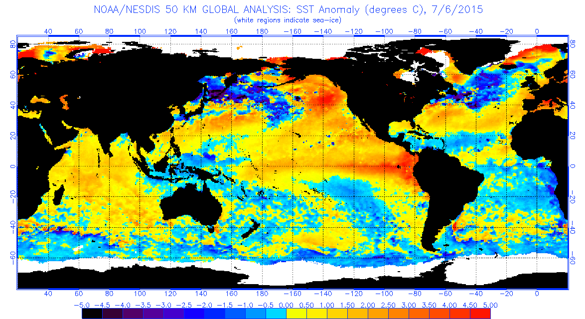
My last update (in May) showed a marginally warm strip along the equator. Now, however, it's July. What do we have here? Well…

Compare that to May, and clearly it's a sign that this event is, hands-down, the strongest since 1997. Do SST anomalies alone tell the whole story? Of course not, but it goes to show just how impressive this event is, with more WWB's and downwelling Kelvin waves (next paragraphs) on the way. What makes this map clearly differ from 2014 (especially) is the Banda Sea cold pool: it forces high pressure over Indonesia, thus keeping the atmospheric response locked in place.
Compare that to May, and clearly it's a sign that this event is, hands-down, the strongest since 1997. Do SST anomalies alone tell the whole story? Of course not, but it goes to show just how impressive this event is, with more WWB's and downwelling Kelvin waves (next paragraphs) on the way. What makes this map clearly differ from 2014 (especially) is the Banda Sea cold pool: it forces high pressure over Indonesia, thus keeping the atmospheric response locked in place.
Westerly trades: Cross-equatorial tropical cyclones, redux
You may recall that what initially kickstarted this event was a pair of tropical cyclones on both sides of the equator at the same longitude back in March: Cyclone Pam (yes, that's right, that monster, the one that ended up being a direct hit on Vanuatu, completely obliterating heavily populated portions of the island) on one side of the equator, and Tropical Storm Bavi (which never made it to typhoon status) on the other. Fast-forward to July 1 Australian time (technically late June 30 in California) and that exact same thing happened again: TS Chan-hom on one side of the equator, Cyclone Raquel (also a TS when the Saffir-Simpson Scale is applied) on the other. Although Cyclone Raquel was clearly weaker than Pam, it was still paired with another cyclone on the opposite side of the equator. When this occurs, it's like a WWB pitching machine: winds rotate counterclockwise north of the equator, clockwise south of it, and between the two, winds have only one way to blow: from W. Here:

As you can clearly see, what we're looking at is easily the most powerful westerly wind burst since March, and moreover, when Raquel dissipated, the Southern Hemisphere Booster followed right behind. Now, there's a pressure gradient of high in W, low in E, which can keep that WWB progressing further E. In ~5 days, this westerly wind burst could reach the far E Pacific, where more hurricanes (starting with Dolores) should form. For a review: the word "typhoon" is only used W of the date line; E of it, they're still hurricanes.
Kelvin waves: 3 and counting
You may recall that the April/May Kelvin wave was set off by the westerly wind burst induced by the Pam/Bavi cross-equatorial pair. However, the May westerly wind burst set off a second downwelling Kelvin wave. While the Kelvin wave in April only contained small patches of +6°C anomalies at depth, this one brought with it anomalies at depth of +6°C across the board, with patchy +7°C T-Depth anomalies. Then, Chan-hom and Raquel pitched in, and the result was a third Kelvin wave. Although it doesn't look too impressive at the moment, it's very fast-moving: in just a matter of, like, 3 days, it's gone from 165°E to the date line, and the WWB that spawned it continues to move east as well. On top of that, there's now a strong MJO superimposed on top of the Niño signal, adding to those westerly anomalies, and as mentioned above, there's also anomalous cooling of the Banda Sea helping to lock that signal in place.
Conclusion
So, we've got everything coupled… it's just a waiting game now. Let's see how strong this event gets, shall we? It would definitely mean the world to us in CA, especially in conjunction with cooling AMO, since cool Atlantic in general tends to want to shift the storm track south, and with the Hudson Bay now also heating up with warm anomalies, blocking should reposition over Canada… everything looks to be coming together. Everyone, this is going to be a wild ride.
No comments:
Post a Comment
Make sure when you comment to be civil and not insult, use profanity, or start flame wars. Anyone who calls people names, uses profanity, uses personal (i.e. ad hominem) attacks towards me, other commenters, open source software leaders, or Jesus, merely skims my blogs instead of reading them thoroughly, spreads FUD from Apple or Microsoft, or in any other way disturbs the peace in discussion will have their comments deleted and ultimately be blocked from this blog.